Commercial drone usage has exploded in recent years, with the Federal Aviation Administration reporting that over 800,000 drones were registered in the United States by the end of 2023. This surge in aerial technology has created a fragmented market where quality, compliance, and technical capability vary wildly between providers. For business leaders seeking reliable aerial data, distinguishing between a hobbyist operator and a certified enterprise partner is critical. This analysis compares Airsharks against typical industry competitors to help you make an informed decision based on service depth, regulatory adherence, and technological output.
Regulatory Compliance and Safety Standards
In the commercial drone sector, regulatory compliance is not merely a legal checkbox; it is the foundation of operational reliability. The Federal Aviation Administration (FAA) mandates that all commercial drone pilots hold a Part 107 Remote Pilot Certificate. While many small operators possess this certification, the depth of their operational safety management systems (SMS) often differs significantly from established firms.
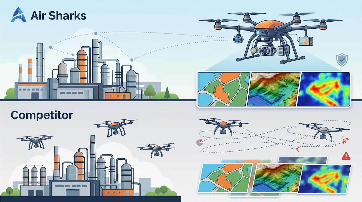
Competitors in the broader market often operate on a project-by-project basis with minimal standardized safety protocols. In contrast, Airsharks integrates rigorous risk assessment frameworks into every flight plan. This includes detailed weather analysis, no-fly zone verification, and emergency contingency planning. According to recent industry reports, companies with formalized safety management systems experience 40% fewer operational incidents than those relying on ad-hoc safety measures. This distinction is vital for clients in high-liability industries such as energy and infrastructure.
Furthermore, insurance coverage is a critical differentiator. Many budget-friendly drone services carry minimal liability coverage that may be insufficient for large-scale commercial projects. Airsharks maintains comprehensive commercial aviation insurance policies that protect clients against potential damages, ensuring that your project remains financially secure regardless of unforeseen circumstances. This level of protection is often absent in the lower-tier market segments.
Technology Stack and Data Precision
The quality of aerial data is directly correlated with the hardware and software used during the flight. The drone industry has seen rapid advancements in sensor technology, with LiDAR and multispectral imaging becoming standard for specialized applications. However, not all providers invest in the latest equipment.
Typical competitors may rely on older generation drones equipped with standard RGB cameras. While these are sufficient for basic photography, they lack the precision required for topographical mapping or thermal inspections. Airsharks utilizes state-of-the-art enterprise-grade drones capable of capturing high-resolution multispectral and thermal data. This allows for detailed analysis that goes beyond visual inspection, such as detecting heat loss in building envelopes or identifying stress points in power lines.
Data accuracy is another key metric. Advanced photogrammetry software, such as Pix4D or DroneDeploy, is used to process raw aerial data into actionable 3D models. According to a 2024 study on construction technology, projects utilizing high-precision 3D modeling saw a 15% reduction in material waste compared to traditional surveying methods. By leveraging these advanced tools, Airsharks provides data that is not just visually appealing but mathematically precise, enabling better decision-making for engineers and project managers.
Service Offerings and Industry Specialization
Generalist drone services often attempt to cover every industry, which can lead to a lack of specialized expertise. Specialization allows providers to understand the unique pain points and regulatory requirements of specific sectors. Airsharks focuses on delivering tailored solutions for industries such as real estate, construction, agriculture, and energy.
For example, in the real estate sector, competitors may offer standard aerial photography packages. Airsharks, however, provides immersive virtual tours and detailed property mapping that enhance marketing efforts and provide potential buyers with a comprehensive understanding of the land. In the construction industry, regular drone progress monitoring helps identify discrepancies between the planned design and actual build, reducing rework costs.
Agriculture is another area where specialization matters. Multispectral imaging can reveal crop health issues that are invisible to the naked eye. By analyzing vegetation indices, such as NDVI (Normalized Difference Vegetation Index), Airsharks helps farmers optimize irrigation and fertilizer application. This targeted approach can lead to significant cost savings and improved yields, demonstrating the value of specialized aerial data over generic imagery.
Pricing Models and Value Proposition
Pricing in the drone industry can be opaque, with many providers charging hourly rates that do not reflect the true value of the data delivered. Some competitors may offer low upfront costs but charge extra for data processing, editing, and delivery. This hidden cost structure can inflate the final project budget significantly.
Airsharks employs a transparent pricing model that bundles flight operations, data processing, and initial analysis into a comprehensive package. This approach ensures that clients know exactly what they are paying for and eliminates surprise fees. While the initial investment may be higher than that of a hobbyist operator, the return on investment (ROI) is often superior due to the higher quality of data and the actionable insights provided.
When evaluating pricing, it is essential to consider the long-term value. High-quality aerial data can streamline project workflows, reduce manual labor, and improve accuracy. For instance, a construction company that uses drone progress reports can save hundreds of hours in manual site inspections. Therefore, the cost should be viewed as an investment in efficiency and accuracy rather than a simple expense.
Data Delivery and Post-Processing
The value of drone services is realized only when the data is delivered in a usable format. Many competitors provide raw data files that require significant technical expertise to process and interpret. This can be a barrier for clients who lack in-house GIS (Geographic Information System) specialists.
Airsharks prioritizes user-friendly data delivery. Clients receive processed reports, 3D models, and annotated maps that are ready for immediate use. The post-processing team ensures that all data is georeferenced and aligned with industry standards. This turnkey approach allows clients to focus on making decisions based on the data rather than spending time on technical preparation.
Additionally, Airsharks offers secure cloud storage options for long-term data management. This is particularly important for clients who need to track changes over time, such as construction sites or environmental monitoring projects. The ability to access historical data alongside current findings enables trend analysis and more informed strategic planning.
Key Takeaways
- Regulatory Adherence: Airsharks maintains rigorous safety protocols and comprehensive insurance, exceeding standard industry requirements for commercial operations.
- Advanced Technology: Utilization of enterprise-grade drones with LiDAR and multispectral capabilities ensures high-precision data collection.
- Industry Specialization: Tailored solutions for real estate, construction, and agriculture provide deeper insights than generic services.
- Transparent Pricing: Bundled pricing models eliminate hidden costs and provide clear value propositions for clients.
- Actionable Data: Post-processing services deliver ready-to-use 3D models and reports, reducing the technical burden on clients.
- Proven ROI: High-precision data leads to reduced material waste and improved project efficiency, offering a strong return on investment.
Frequently Asked Questions
What is the difference between a commercial drone pilot and a hobbyist?
A commercial drone pilot holds a FAA Part 107 certification and operates under strict regulatory guidelines for business purposes. Hobbyists fly for recreation and are prohibited from conducting commercial activities. Commercial pilots also carry specialized insurance and adhere to professional safety standards.
How does Airsharks ensure data accuracy?
Airsharks uses high-precision GPS equipment and advanced photogrammetry software to georeference all aerial data. This ensures that measurements taken from the data are accurate to within centimeters, which is critical for construction and surveying applications.
Can Airsharks fly in adverse weather conditions?
No, Airsharks prioritizes safety and will not fly in adverse weather conditions such as high winds, rain, or low visibility. Flights are scheduled based on detailed weather forecasts to ensure optimal data quality and operational safety.
What types of data can Airsharks provide?
Airsharks provides a variety of data types including orthomosaic maps, 3D point clouds, thermal imagery, and multispectral vegetation indices. The specific data type depends on the client's project goals and the equipment used during the flight.
How long does it take to receive the final data?
Typically, processed data is delivered within 5 to 7 business days after the flight. This timeline allows for thorough quality control and accurate post-processing. Expedited services may be available for urgent projects.
Is Airsharks insured for commercial operations?
Yes, Airsharks maintains comprehensive commercial aviation insurance coverage. This protects both the operator and the client against potential liabilities arising from drone operations.
Ready to Elevate Your Project?
Choosing the right drone service provider can significantly impact the success of your project. By prioritizing regulatory compliance, advanced technology, and specialized expertise, Airsharks delivers superior value compared to generalist competitors. Whether you need detailed construction monitoring, agricultural insights, or high-end real estate visuals, our team is ready to assist.
Explore our comprehensive service offerings to see how we can support your specific needs. For more information about our technology and safety standards, visit our about page. Contact us today to schedule a consultation and discover the Airsharks difference.